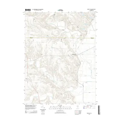
2015 Map of Perry East
USGS Topo · Published 2015About this map
Chambersburg and Perry anchor this rural landscape along the border of Brown and Pike Counties, where the terrain is defined by the winding course of McKee Creek and its many tributaries. The area is marked by a high density of small family and community burial sites, including the Suratt Burial Ground, Newenham Cem, and Varder Cem, offering significant value for genealogical research in this part of Illinois. The landscape transitions from the creek bottoms to the upland farms, connected by local routes like Co Highway 5 and distinctive crossings such as the Ritter Bridge. Water management is a visible priority here, evidenced by the series of tiered reservoirs known as Hambaugh-Martin Number 1, Number 2, and Number 3, alongside De Frates Shaeffer Lake. This network of small-scale water features and scattered cemeteries illustrates the enduring agricultural and family-centered character of the region.
Find a feature on this map
61 named features on this map. Tap any name to fly to it.
Don’t see what you’re looking for? This feature index may not catch every label — zoom into the map to look around manually.
Map Details
Editions of this 2015 Perry East Map
This is the sole edition of this map. No revisions or reprints were ever made.
Other maps of this area

1924 · Griggsville
USGS Topo · 1:62,500

1926 · Griggsville
USGS Topo · 1:62,500

1926 · Pittsfield
USGS Topo · 1:62,500

1926 · Mt Sterling
USGS Topo · 1:62,500

1928 · Meredosia
USGS Topo · 1:62,500

1929 · Mt Sterling
USGS Topo · 1:62,500

1931 · Meredosia
USGS Topo · 1:62,500

1948 · Quincy
USGS Topo · 1:250,000

1956 · Quincy
USGS Topo · 1:250,000
1975 · Meredosia SE
USGS Topo · 1:24,000