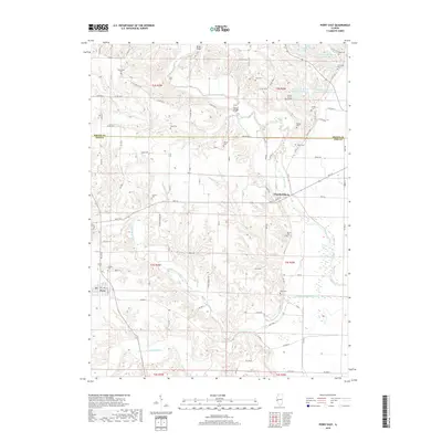
2018 Map of Perry East
USGS Topo · Published 2018About this map
McKee Creek and its many branches, including the Middle Fork McKee Cr and South Fork McKee Creek, dominate this landscape at the border of Brown and Pike Counties. The village of Chambersburg sits near a prominent bend in the creek, while Perry anchors the western edge of the quadrangle. The area is defined by its deep genealogical footprint, with numerous family-named burial sites scattered across the township lines. Noteworthy locations include the Suratt Burial Ground, Newenham Cem, and Calhoun Cem, which offer significant points of interest for local historians. Infrastructure is primarily rural, marked by landmarks like the Ritter Bridge and Varder Bridge crossing the winding waterways. The map also details several agricultural water management features, such as the Hambaugh-Martin Number 1 Reservoir, reflecting the region's reliance on the creek system for local land use.
Find a feature on this map
109 named features on this map. Tap any name to fly to it.
Don’t see what you’re looking for? This feature index may not catch every label — zoom into the map to look around manually.
Map Details
Editions of this 2018 Perry East Map
This is the sole edition of this map. No revisions or reprints were ever made.
Other maps of this area

1924 · Griggsville
USGS Topo · 1:62,500

1926 · Griggsville
USGS Topo · 1:62,500

1926 · Pittsfield
USGS Topo · 1:62,500

1926 · Mt Sterling
USGS Topo · 1:62,500

1928 · Meredosia
USGS Topo · 1:62,500

1929 · Mt Sterling
USGS Topo · 1:62,500

1931 · Meredosia
USGS Topo · 1:62,500

1948 · Quincy
USGS Topo · 1:250,000

1956 · Quincy
USGS Topo · 1:250,000
1975 · Meredosia SE
USGS Topo · 1:24,000