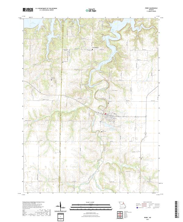
2021 Map of Perry
USGS Topo · Published 2021About this map
Perry and the surrounding rural landscapes of Ralls and Monroe counties are defined by the winding tributaries of Mark Twain Lake and the traditional agricultural grid of northern Missouri. The town itself serves as a local hub, situated near Perry City Lake and Perry City Lake Upper, while the small settlement of Greenlawn sits further north. The terrain is deeply etched by a network of waterways, including Lick Creek, Burbridge Cr, and Pigeon Roost Cr, which carve through the farmland. Genealogists will find a high concentration of burial sites throughout this quadrangle, such as Scobee Cem, Wolf Cem, Lick Creek Cem, and Muldrow Cem, many of which are located near old farm roads like Monroe Co Rd 680. Aviation history is represented by the Wood Acres Airport located near the county line, while the presence of Prairie Cem near Old Mount Prairie Cem suggests the historical importance of early prairie settlements in this region.
Find a feature on this map
91 named features on this map. Tap any name to fly to it.
Don’t see what you’re looking for? This feature index may not catch every label — zoom into the map to look around manually.
Map Details
Editions of this 2021 Perry Map
This is the sole edition of this map. No revisions or reprints were ever made.