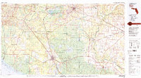
1979 Map of Perry
USGS Topo · Published 1980About this map
The blackwater rivers of North Central Florida define the landscape of this 1970s survey, where the Suwannee River and Withlacoochee River meet at Suwannee River State Park. This region, spanning several county lines including Taylor, Madison, and Lafayette, reflects a mid-century economy built on timber and transit. The city of Perry serves as a central hub, supported by the Perry-Foley Airport and industrial rail corridors like the Seaboard Coast Line. To the west, the swampy coastal reaches of Apalachee Bay and the Gulf of Mexico appear near the Hickory Mound Impoundment, showing a largely undeveloped shoreline. Inland, the map documents a network of rural settlements such as Shady Grove, Day, and Luraville, along with several fire watch stations like the Sinclair Lookout Tower, which monitored the expansive pine forests of the Big Bend region.
Find a feature on this map
53 named features on this map. Tap any name to fly to it.
Don’t see what you’re looking for? This feature index may not catch every label — zoom into the map to look around manually.
Map Details
Editions of this 1979 Perry Map
2 editions found
Other maps of this area

1949 · Apalachicola
USGS Topo · 1:250,000

1952 · Secotan
USGS Topo · 1:24,000

1954 · Mallory Swamp NW
USGS Topo · 1:24,000

1954 · Fenholloway
USGS Topo · 1:24,000

1954 · Day SE
USGS Topo · 1:24,000

1954 · Johnson Hammock
USGS Topo · 1:24,000

1954 · Day
USGS Topo · 1:24,000

1954 · Cooks Hammock
USGS Topo · 1:24,000

1954 · Warrior Swamp
USGS Topo · 1:24,000

1954 · Salem
USGS Topo · 1:24,000