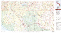
1979 Map of Perry
USGS Topo · Published 1980About this map
Perry and Madison serve as the primary hubs in this late-1970s landscape, where the northern Florida panhandle meets the Gulf. The region is defined by a dense network of timberlands and wetlands, most notably the expansive San Pedro Bay and Hixtown Swamp. Waterways dictate the layout of the land, with the Suwannee River and Withlacoochee River converging near Suwannee River State Park.
Find a feature on this map
73 named features on this map. Tap any name to fly to it.
Don’t see what you’re looking for? This feature index may not catch every label — zoom into the map to look around manually.
Map Details
Editions of this 1979 Perry Map
2 editions found
Other maps of this area

1949 · Apalachicola
USGS Topo · 1:250,000

1952 · Secotan
USGS Topo · 1:24,000

1954 · Mallory Swamp NW
USGS Topo · 1:24,000

1954 · Fenholloway
USGS Topo · 1:24,000

1954 · Day SE
USGS Topo · 1:24,000

1954 · Johnson Hammock
USGS Topo · 1:24,000

1954 · Day
USGS Topo · 1:24,000

1954 · Cooks Hammock
USGS Topo · 1:24,000

1954 · Warrior Swamp
USGS Topo · 1:24,000

1954 · Salem
USGS Topo · 1:24,000