
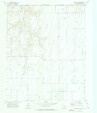
1973 Map of Perryton SE
USGS Topo · Published 1976About this map
The northern High Plains landscape of Ochiltree County in the early 1970s is defined by a dense network of energy infrastructure and the deep incision of Wolf Creek across the southern half of the sheet. The southern edge of Perryton is visible in the north, featuring a Hospital, a Golf Course, and a Radio Tower. The era's oil and gas production is evidenced by numerous unnamed wells and significant Pipelines that traverse the terrain, supported by a Pumping Station near the center of the survey. Historically significant landmarks include the Ochiltree Cemetery, which sits on the plateau overlooking the rugged draws feeding into the creek valley. Further south, the Perryton Country Club and a Water Tank mark the recreational limits of the area, while the Atchison Topeka and Santa Fe railroad line clips the northwestern corner.
Find a feature on this map
17 named features on this map. Tap any name to fly to it.
Don’t see what you’re looking for? This feature index may not catch every label — zoom into the map to look around manually.
Map Details
Editions of this 1973 Perryton SE Map
This is the sole edition of this map. No revisions or reprints were ever made.
Other maps of this area

1954 · Perryton
USGS Topo · 1:250,000

1958 · Perryton
USGS Topo · 1:250,000

1973 · Farnsworth
USGS Topo · 1:24,000

1973 · Booker SW
USGS Topo · 1:24,000

1973 · Sourdough Creek NE
USGS Topo · 1:24,000

1973 · Perryton
USGS Topo · 1:24,000

1973 · Lake Fryer
USGS Topo · 1:24,000

1973 · Sourdough Creek NW
USGS Topo · 1:24,000

1973 · Huntoon
USGS Topo · 1:24,000
1973 · Perryton NW
USGS Topo · 1:24,000