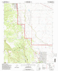
1995 Map of Petaca Peak
USGS Topo · Published 1998About this map
Petaca Grant lands define the southwestern reaches of this survey, where the high-elevation terrain of Petaca Mesa and Red Mesa overlooks the landscape. The prominent Petaca Peak serves as a central landmark within the Tres Piedras Ranger District of the Carson National Forest. This mid-1990s record captures a rural environment dictated by water management and resource extraction, evidenced by a dense network of catchment tanks such as Owl Trick Tank, Servilleta Tank, and Petaca Tank A.
Find a feature on this map
40 named features on this map. Tap any name to fly to it.
Don’t see what you’re looking for? This feature index may not catch every label — zoom into the map to look around manually.
Map Details
Editions of this 1995 Petaca Peak Map
This is the sole edition of this map. No revisions or reprints were ever made.
Other maps of this area

1918 · Abiquiu
USGS Topo · 1:125,000

1918 · Tusas
USGS Topo · 1:125,000

1953 · La Madera
USGS Topo · 1:24,000

1954 · Raton
USGS Topo · 1:250,000

1954 · Aztec
USGS Topo · 1:250,000

1958 · Raton
USGS Topo · 1:250,000

1958 · Aztec
USGS Topo · 1:250,000

1961 · Tres Orejas
USGS Topo · 1:24,000

1961 · Servilleta Plaza
USGS Topo · 1:24,000

1962 · Aztec
USGS Topo · 1:250,000