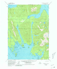
1953 Map of Petersburg A-2
USGS Topo · Published 1981About this map
Etolin Island dominates this mid-century maritime landscape, defined by a complex network of deep-water channels and rugged peaks. The surveying recorded in the 1950s highlights the critical water passages of the Alexander Archipelago, including Burnett Inlet and Mosman Inlet, which slice deep into the island's interior. Human activity is concentrated along the shorelines, evidenced by Cannery Pt and scattered Cabins, indicating the area's reliance on the local fishing industry and seasonal outposts. Inland, the terrain rises sharply to named summits like Alice Peak and Virginia Peak, while coastal features such as Jadski Cove and Cooney Cove suggest the many natural harbors used by vessels navigating the Stikine Strait. The map integrates hydrographic data from several decades, showing the evolution of maritime knowledge in Southeast Alaska.
Find a feature on this map
45 named features on this map. Tap any name to fly to it.
Don’t see what you’re looking for? This feature index may not catch every label — zoom into the map to look around manually.
Map Details
Editions of this 1953 Petersburg A-2 Map
3 editions found

Other maps of this area

1948 · Petersburg A-1
USGS Topo · 1:63,360

1948 · Petersburg A-2
USGS Topo · 1:63,360

1948 · Petersburg B-2
USGS Topo · 1:63,360

1948 · Petersburg B-1
USGS Topo · 1:63,360

1948 · Petersburg B-3
USGS Topo · 1:63,360

1949 · Craig D-3
USGS Topo · 1:63,360

1949 · Craig D-2
USGS Topo · 1:63,360

1949 · Petersburg A-3
USGS Topo · 1:63,360

1949 · Craig D-1
USGS Topo · 1:63,360

1950 · Craig D-3
USGS Topo · 1:63,360