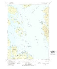
1949 Map of Petersburg A-3
USGS Topo · Published 1975About this map
Etolin Island and Prince of Wales Island dominate this coastal survey, where the intricate waterways of Southeast Alaska's Alexander Archipelago are meticulously documented. The map highlights a complex maritime environment within the Tongass National Forest, centered around Kashevarof Passage and the broad expanse of Clarence Strait. Landforms range from the larger Zarembo Island to small clusters like the Blashke Islands and Screen Islands, illustrating the navigational challenges of these fjords and channels.
Find a feature on this map
33 named features on this map. Tap any name to fly to it.
Don’t see what you’re looking for? This feature index may not catch every label — zoom into the map to look around manually.
Map Details
Editions of this 1949 Petersburg A-3 Map
3 editions found
Other maps of this area

1948 · Petersburg A-2
USGS Topo · 1:63,360

1948 · Petersburg B-2
USGS Topo · 1:63,360

1948 · Petersburg B-3
USGS Topo · 1:63,360

1949 · Craig D-3
USGS Topo · 1:63,360

1949 · Craig D-2
USGS Topo · 1:63,360

1949 · Petersburg A-3
USGS Topo · 1:63,360

1949 · Craig D-4
USGS Topo · 1:63,360

1949 · Petersburg A-4
USGS Topo · 1:63,360

1949 · Petersburg B-4
USGS Topo · 1:63,360

1950 · Craig D-3
USGS Topo · 1:63,360