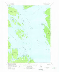
1949 Map of Petersburg A-3
USGS Topo · Published 1975About this map
Clarence Strait and the Kashevarof Passage define the complex maritime landscape of this 1949 survey, which captures the coastal geography of the Tongass National Forest before modern developments. The map reveals the intricate shoreline of northern Prince of Wales Island and neighboring Etolin Island, where the economy and movement were entirely dictated by the tides and inlets. A notable point of historical interest is the Cannery (Aban'd) located near Lake Bay, signaling the transient nature of the early 20th-century salmon industry in the region. The interior of these islands, such as Stevenson Island, shows a network of water bodies like Barnes Lake and Indian Creek, which provided essential freshwater access and transport routes for those navigating the Alexander Archipelago during this post-war era of Alaskan territorial history.
Find a feature on this map
33 named features on this map. Tap any name to fly to it.
Don’t see what you’re looking for? This feature index may not catch every label — zoom into the map to look around manually.
Map Details
Editions of this 1949 Petersburg A-3 Map
3 editions found
Other maps of this area

1948 · Petersburg A-2
USGS Topo · 1:63,360

1948 · Petersburg B-2
USGS Topo · 1:63,360

1948 · Petersburg B-3
USGS Topo · 1:63,360

1949 · Craig D-3
USGS Topo · 1:63,360

1949 · Craig D-2
USGS Topo · 1:63,360

1949 · Petersburg A-3
USGS Topo · 1:63,360

1949 · Craig D-4
USGS Topo · 1:63,360

1949 · Petersburg A-4
USGS Topo · 1:63,360

1949 · Petersburg B-4
USGS Topo · 1:63,360

1950 · Craig D-3
USGS Topo · 1:63,360