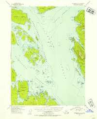
1953 Map of Petersburg A-3
USGS Topo · Published 1954About this map
Clarence Strait and Stikine Strait converge in this mid-century maritime study of the Alexander Archipelago. The landscape is defined by the complex waterways of the Kashevarof Islands and the Blashke Islands, providing a detailed look at the hazardous coastal navigation of the era. Evidence of the region's commercial fishing history is visible at Lake Bay, where a Cannery (Aband) sits near the Lake Bay Mag Sta. The map captures a transitional moment for the Tongass National Forest, detailing natural harbors like Steamer Bay and Kindergarten Bay on the western edge of Etolin Island. Significant landmarks for mariners, including Pt Nesbitt and Key Reef, anchor the nautical character of this rugged Southeast Alaska terrain.
Find a feature on this map
70 named features on this map. Tap any name to fly to it.
Don’t see what you’re looking for? This feature index may not catch every label — zoom into the map to look around manually.
Map Details
Editions of this 1953 Petersburg A-3 Map
2 editions found

Other maps of this area

1948 · Petersburg A-2
USGS Topo · 1:63,360

1948 · Petersburg B-2
USGS Topo · 1:63,360

1948 · Petersburg B-3
USGS Topo · 1:63,360

1949 · Craig D-3
USGS Topo · 1:63,360

1949 · Craig D-2
USGS Topo · 1:63,360

1949 · Petersburg A-3
USGS Topo · 1:63,360

1949 · Craig D-4
USGS Topo · 1:63,360

1949 · Petersburg A-4
USGS Topo · 1:63,360

1949 · Petersburg B-4
USGS Topo · 1:63,360

1950 · Craig D-3
USGS Topo · 1:63,360