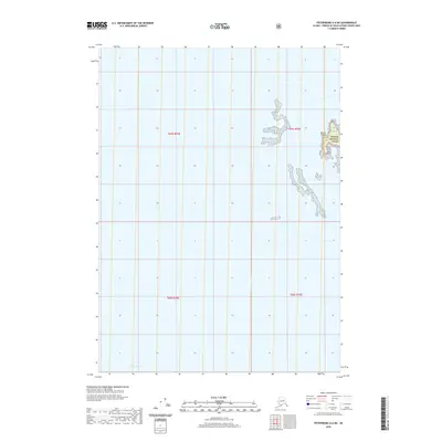
2020 Map of Petersburg A-6 NE
USGS Topo · Published 2020About this map
Sumner Strait dominates this 2020 topographic record, illustrating a segment of the Alexander Archipelago where the open waters of the passage meet the eastern shoreline. The map focuses on the complex coastal interface within the Tongass National Forest, detailing the numerous small landmasses and outcrops that comprise the Barrier Islands. These islands are critical maritime landmarks in the treacherous waters of southeast Alaska, serving as natural buffers along the strait. The absence of roads or permanent settlements emphasizes the isolation of this maritime environment, highlighting a landscape defined entirely by its hydrography and federally protected forest lands. This survey captures the exact shoreline and coastal topography as it existed at the beginning of the 2020s, providing a precise spatial reference for the southeastern edge of Petersburg Borough.
Find a feature on this map
7 named features on this map. Tap any name to fly to it.
Don’t see what you’re looking for? This feature index may not catch every label — zoom into the map to look around manually.
Map Details
Editions of this 2020 Petersburg A-6 NE Map
This is the sole edition of this map. No revisions or reprints were ever made.
Other maps of this area

1948 · Petersburg A-6
USGS Topo · 1:63,360

1948 · Petersburg B-6
USGS Topo · 1:63,360

1949 · Petersburg B-5
USGS Topo · 1:63,360

1949 · Petersburg A-5
USGS Topo · 1:63,360

1951 · Petersburg B-6
USGS Topo · 1:63,360

1951 · Petersburg A-6
USGS Topo · 1:63,360

1952 · Petersburg
USGS Topo · 1:250,000
1953 · Petersburg B-5
USGS Topo · 1:63,360

1953 · Petersburg A-5
USGS Topo · 1:63,360

1960 · Petersburg
USGS Topo · 1:250,000