
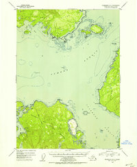
1951 Map of Petersburg B-4
USGS Topo · Published 1954About this map
Sumner Strait and Clarence Strait converge in this mid-century maritime survey of Southeast Alaska, where the northern tip of Prince of Wales Island meets the jagged coastlines of Kupreanof Island and Zarembo Island. Navigational safety in these volatile waters is marked by vital landmarks such as Vichnefski Rock Light and The Eye Opener Light, while the inland topography reveals a system of freshwater drainage including Red Lake and Salmon Lake.
Find a feature on this map
52 named features on this map. Tap any name to fly to it.
Don’t see what you’re looking for? This feature index may not catch every label — zoom into the map to look around manually.
Map Details
Editions of this 1951 Petersburg B-4 Map
2 editions found
Other maps of this area

1948 · Petersburg C-4
USGS Topo · 1:63,360

1948 · Petersburg C-3
USGS Topo · 1:63,360

1948 · Petersburg C-5
USGS Topo · 1:63,360

1948 · Petersburg B-3
USGS Topo · 1:63,360

1949 · Petersburg B-5
USGS Topo · 1:63,360

1949 · Petersburg A-3
USGS Topo · 1:63,360

1949 · Petersburg A-5
USGS Topo · 1:63,360

1949 · Petersburg A-4
USGS Topo · 1:63,360

1949 · Petersburg B-4
USGS Topo · 1:63,360

1951 · Petersburg B-3
USGS Topo · 1:63,360