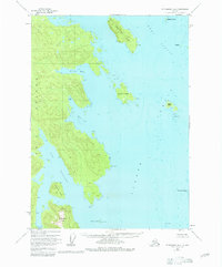
1951 Map of Petersburg B-6
USGS Topo · Published 1981About this map
Kuiu Island dominates this 1950s coastal survey, showcasing the intricate shoreline of the Tongass National Forest along the Alexander Archipelago. The maritime landscape is defined by the deep inlet of Port Beauclerc and the prominent Beauclerc Peak, providing a snapshot of the region's topography before significant modern development. Navigational hazards and coastal features are meticulously charted, including the scattered rocks of Mariposa Reef and Calder Rocks in the surrounding straits.
Find a feature on this map
19 named features on this map. Tap any name to fly to it.
Don’t see what you’re looking for? This feature index may not catch every label — zoom into the map to look around manually.
Map Details
Editions of this 1951 Petersburg B-6 Map
3 editions found

Other maps of this area

1948 · Port Alexander C-1
USGS Topo · 1:63,360

1948 · Petersburg A-6
USGS Topo · 1:63,360

1948 · Port Alexander A-1
USGS Topo · 1:63,360

1948 · Petersburg B-6
USGS Topo · 1:63,360

1948 · Port Alexander B-1
USGS Topo · 1:63,360

1948 · Petersburg C-6
USGS Topo · 1:63,360

1948 · Petersburg C-5
USGS Topo · 1:63,360

1949 · Petersburg B-5
USGS Topo · 1:63,360

1949 · Petersburg A-5
USGS Topo · 1:63,360

1951 · Port Alexander
USGS Topo · 1:250,000