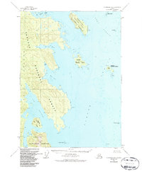
1951 Map of Petersburg B-6
USGS Topo · Published 1987About this map
Tongass National Forest encompasses the rugged island geography of this coastal Alaskan landscape, where maritime navigation is the primary shaper of human activity. The map centers on the intricate waterways of Port Beauclerc and Reid Bay, flanked by the significant heights of Beauclerc Peak. Evidence of local habitation and seasonal use appears in the form of scattered Cabin and Cabins labels, particularly near the sheltered shores of Sumner Island and Conclusion Island. Navigational safety for the surrounding Sumner Strait is anchored by the presence of Beauclerc Light, positioned at the entrance to the port. This 1951 record, updated through the 1980s, captures a wilderness area defined by its named points and rocks, such as Boulder Pt and Calder Rocks, which delineate the hazards and harbors used by generations of mariners in the Alexander Archipelago.
Find a feature on this map
21 named features on this map. Tap any name to fly to it.
Don’t see what you’re looking for? This feature index may not catch every label — zoom into the map to look around manually.
Map Details
Editions of this 1951 Petersburg B-6 Map
3 editions found

Other maps of this area

1948 · Port Alexander C-1
USGS Topo · 1:63,360

1948 · Petersburg A-6
USGS Topo · 1:63,360

1948 · Port Alexander A-1
USGS Topo · 1:63,360

1948 · Petersburg B-6
USGS Topo · 1:63,360

1948 · Port Alexander B-1
USGS Topo · 1:63,360

1948 · Petersburg C-6
USGS Topo · 1:63,360

1948 · Petersburg C-5
USGS Topo · 1:63,360

1949 · Petersburg B-5
USGS Topo · 1:63,360

1949 · Petersburg A-5
USGS Topo · 1:63,360

1951 · Port Alexander
USGS Topo · 1:250,000