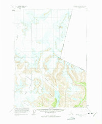
1961 Map of Petersburg D-1
USGS Topo · Published 1975About this map
Tongass National Forest dominates this Alaskan landscape, characterized by a massive network of active ice flows and alpine peaks. The glacial system is anchored by the Le Conte Glacier and the expansive Shakes Glacier, which terminates near the waters of Shakes Lake. This 1961 survey, based on aerial photography from the late 1940s and early 1960s, documents the international boundary between Alaska and British Columbia. High-elevation landmarks such as Mount Pratt, Castle Mountain, and Boundary Peak 69 7329 serve as the primary navigational points along the jagged United States-Canada border. Smaller flows like Summit Glacier and Popof Glacier further illustrate the dense ice coverage that defines this uninhabited wilderness.
Find a feature on this map
12 named features on this map. Tap any name to fly to it.
Don’t see what you’re looking for? This feature index may not catch every label — zoom into the map to look around manually.
Map Details
Editions of this 1961 Petersburg D-1 Map
3 editions found

Other maps of this area

1948 · Petersburg C-1
USGS Topo · 1:63,360

1948 · Petersburg C-2
USGS Topo · 1:63,360

1951 · Bradfield Canal
USGS Topo · 1:250,000

1951 · Petersburg C-2
USGS Topo · 1:63,360

1952 · Petersburg
USGS Topo · 1:250,000

1952 · Sumdum
USGS Topo · 1:250,000

1953 · Petersburg C-1
USGS Topo · 1:63,360

1954 · Bradfield Canal
USGS Topo · 1:250,000

1955 · Bradfield canal D-6
USGS Topo · 1:63,360

1955 · Bradfield canal C-6
USGS Topo · 1:63,360