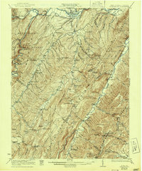
1922 Map of Petersburg
USGS Topo · Published 1944About this map
Petersburg stands as the primary hub of this Potomac Highlands landscape, situated where the Baltimore and Ohio railroad meets the winding South Br Potomac R. The map captures a transition era in West Virginia's eastern panhandle, where early industry like the Glen Mill operated alongside a dense network of mountain communities. The terrain is marked by steep ridges and dramatic breaks such as North Fork Gap, which shaped the placement of local schools and churches.
Find a feature on this map
79 named features on this map. Tap any name to fly to it.
Don’t see what you’re looking for? This feature index may not catch every label — zoom into the map to look around manually.
Map Details
Editions of this 1922 Petersburg Map
2 editions found

Other maps of this area

1891 · Romney
USGS Topo · 1:125,000

1892 · Franklin
USGS Topo · 1:125,000

1892 · Woodstock
USGS Topo · 1:125,000

1895 · Piedmont
USGS Topo · 1:125,000

1896 · Franklin
USGS Topo · 1:125,000

1916 · Davis
USGS Topo · 1:48,000

1918 · Davis
USGS Topo · 1:62,500

1919 · Davis
USGS Topo · 1:62,500

1920 · Davis
USGS Topo · 1:48,000

1920 · Petersburg
USGS Topo · 1:48,000