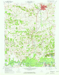
1961 Map of Petersburg
USGS Topo · Published 1963About this map
The White River forms a natural northern boundary for this 1960s landscape, where the town of Petersburg serves as the focal point for Pike County. The surrounding terrain is a mosaic of small rural settlements like Glezen and Willisville connected by an intricate network of rail lines and early township roads. Industrial activity is visible in the rail infrastructure of the New York Central and the proximity of a Strip Mine to the east, contrasting with the preserved lands of the Pike County State Forest along the southern bend of the Patoka River.
Find a feature on this map
69 named features on this map. Tap any name to fly to it.
Don’t see what you’re looking for? This feature index may not catch every label — zoom into the map to look around manually.
Map Details
Editions of this 1961 Petersburg Map
3 editions found
Other maps of this area

1902 · Ditney
USGS Topo · 1:125,000

1903 · Velpen
USGS Topo · 1:62,500

1903 · Petersburg
USGS Topo · 1:62,500

1944 · Monroe City
USGS Topo · 1:24,000

1944 · Iona
USGS Topo · 1:24,000

1945 · Sandy Hook
USGS Topo · 1:24,000

1956 · Vincennes
USGS Topo · 1:250,000

1957 · Vincennes
USGS Topo · 1:250,000

1958 · Vincennes
USGS Topo · 1:250,000
1958 · Monroe City
USGS Topo · 1:24,000