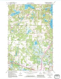
1972 Map of Peterson Lake
USGS Topo · Published 1995About this map
The glacial landscape of Beltrami County is defined here by a dense network of lakes and marshes, ranging from the large Turtle Lake to the smaller Meadow Lake and Alice Lake. This 1972 survey captures a rural landscape undergoing modern transitions, evidenced by the presence of the Bemidji Municipal Airport and a Drive-in Theater near the southern corporate boundary. A notable historical boundary, the Treaty Boundary, cuts through the northern section near the small settlement of Werner. Rural community life is anchored by institutions like Northern Sch, Northern Cem, and the Chapel in the Pines. To the east and west, the map details the protected lands of the Buena Vista State Forest and Mississippi State Headwaters Forest, while the defunct Old Grade hints at earlier logging or rail transport corridors that once traversed these woods.
Find a feature on this map
28 named features on this map. Tap any name to fly to it.
Don’t see what you’re looking for? This feature index may not catch every label — zoom into the map to look around manually.
Map Details
Editions of this 1972 Peterson Lake Map
2 editions found
Other maps of this area

1919 · Solway
USGS Topo · 1:62,500

1920 · Buena Vista
USGS Topo · 1:62,500

1943 · Solway
USGS Topo · 1:62,500

1954 · Bemidji
USGS Topo · 1:250,000

1957 · Bemidji
USGS Topo · 1:250,000

1958 · Bemidji
USGS Topo · 1:250,000

1968 · Bemidji East
USGS Topo · 1:24,000

1968 · Bemidji West
USGS Topo · 1:24,000

1972 · Peterson Lake
USGS Topo · 1:24,000

1972 · White Fish Lake
USGS Topo · 1:24,000