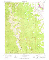
1955 Map of Peterson
USGS Topo · Published 1978About this map
Peterson sits at the edge of the Morgan Valley, where the Weber River and the Union Pacific railroad corridor provide a vital transit link through the Wasatch Range. The settlement is anchored by the Peterson Cem, while the surrounding terrain is defined by a dense network of drainage forks including Right Hand Fork Peterson Creek and Left Hand Fork Dalton Creek.
Find a feature on this map
44 named features on this map. Tap any name to fly to it.
Don’t see what you’re looking for? This feature index may not catch every label — zoom into the map to look around manually.
Map Details
Editions of this 1955 Peterson Map
5 editions found
Other maps of this area

1885 · Salt Lake
USGS Topo · 1:250,000

1925 · Ft. Douglas
USGS Topo · 1:125,000

1928 · Ft. Douglas
USGS Topo · 1:125,000

1952 · Farmington
USGS Topo · 1:24,000

1952 · Bountiful Peak
USGS Topo · 1:24,000

1954 · Salt Lake City
USGS Topo · 1:250,000

1954 · Ogden
USGS Topo · 1:250,000

1955 · Ogden
USGS Topo · 1:24,000

1955 · Peterson
USGS Topo · 1:24,000

1955 · Kaysville
USGS Topo · 1:24,000