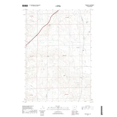
2017 Map of Pfeiffer Hill
USGS Topo · Published 2017About this map
Pfeiffer Hill and the Kaiser Divide form the topographic spine of this Wyoming landscape, where the high-altitude terrain of Crook County is marked by a network of seasonal drainages and cattle-country infrastructure. The map reveals a ranching landscape defined by scattered peaks like O'Haver Hill and Bock Hill, connected by a long-established road network that follows the natural contours of the land. The Sundance-Wind River Rd cuts through the northern section, while lower elevations such as Black Flats and Schelldorf Draw indicate the drainage patterns for Mason Creek and Beaver Cr. This 2017 survey provides a detailed record of land use in the High Plains, showing how contemporary section lines and rural routes like Coal Divide Rd and Douglas Rd continue to respect the complex geology of the Black Hills foothills.
Find a feature on this map
32 named features on this map. Tap any name to fly to it.
Don’t see what you’re looking for? This feature index may not catch every label — zoom into the map to look around manually.
Map Details
Editions of this 2017 Pfeiffer Hill Map
This is the sole edition of this map. No revisions or reprints were ever made.
Other maps of this area

1898 · Sundance
USGS Topo · 1:125,000

1902 · Sundance
USGS Topo · 1:125,000

1918 · Moorcroft
USGS Topo · 1:125,000

1954 · Gillette
USGS Topo · 1:250,000

1955 · Gillette
USGS Topo · 1:250,000

1957 · Nefsy Divide
USGS Topo · 1:62,500

1957 · Upton
USGS Topo · 1:62,500

1958 · Gillette
USGS Topo · 1:250,000
1958 · Inyan Kara Mountain
USGS Topo · 1:62,500

1958 · Sundance
USGS Topo · 1:62,500