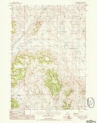
1984 Map of Pfeiffer Hill
USGS Topo · Published 1985About this map
Pfeiffer Hill and the surrounding high plains of Crook County dominate this 1980s landscape, captured just before modern development altered these remote drainages. The area is defined by a complex network of seasonal watercourses and ridges, most notably the Kaiser Divide which separates the north-flowing waters of Benton Creek and Beaver Creek from the southern reaches of Inyan Kara Creek.
Find a feature on this map
19 named features on this map. Tap any name to fly to it.
Don’t see what you’re looking for? This feature index may not catch every label — zoom into the map to look around manually.
Map Details
Editions of this 1984 Pfeiffer Hill Map
This is the sole edition of this map. No revisions or reprints were ever made.
Other maps of this area

1898 · Sundance
USGS Topo · 1:125,000

1902 · Sundance
USGS Topo · 1:125,000

1918 · Moorcroft
USGS Topo · 1:125,000

1954 · Gillette
USGS Topo · 1:250,000

1955 · Gillette
USGS Topo · 1:250,000

1957 · Nefsy Divide
USGS Topo · 1:62,500

1957 · Upton
USGS Topo · 1:62,500

1958 · Gillette
USGS Topo · 1:250,000
1958 · Inyan Kara Mountain
USGS Topo · 1:62,500

1958 · Sundance
USGS Topo · 1:62,500