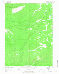
1961 Map of Phantom Lake
USGS Topo · Published 1968About this map
Medicine Bow National Forest dominates this 1961 field-checked landscape, where the high ridges and drainages of Carbon County reveal a history of resource extraction and mountain surveillance. The presence of the Slash Ridge Lookout atop Slash Ridge highlights the era's reliance on fire spotting towers for forest management. To the east, the topography includes Phantom Lake and the nearby Stamp Mill Lake, names that suggest the area's prospecting past, specifically along the banks of Arrastre Creek. The map details a complex network of alpine waterways, including the headwaters of North French Creek and South Brush Creek, providing a clear record of the watershed prior to modern developments. This high-altitude terrain, marked by Barrett Ridge and Middle French Creek, serves as a precise document of mid-century federal forest administration in the Wyoming mountains.
Find a feature on this map
18 named features on this map. Tap any name to fly to it.
Don’t see what you’re looking for? This feature index may not catch every label — zoom into the map to look around manually.
Map Details
Editions of this 1961 Phantom Lake Map
3 editions found
Other maps of this area

1906 · Medicine Bow
USGS Topo · 1:125,000

1908 · Medicine Bow
USGS Topo · 1:125,000

1939 · Saratoga
USGS Topo · 1:125,000

1954 · Rawlins
USGS Topo · 1:250,000

1958 · Rawlins
USGS Topo · 1:250,000

1961 · Overlook Hill
USGS Topo · 1:24,000

1961 · Ryan Park
USGS Topo · 1:24,000

1961 · Sand Lake
USGS Topo · 1:24,000
1961 · Kennaday Peak
USGS Topo · 1:24,000

1961 · Medicine Bow Peak
USGS Topo · 1:24,000