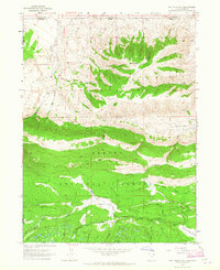
1963 Map of Phil Pico Mtn
USGS Topo · Published 1965About this map
Phil Pico Mountain dominates this 1963 survey of the high-altitude terrain along the Utah-Wyoming state line. This rugged section of the Ashley National Forest is defined by a series of steep drainages and peaks, including Corson Peak, which reaches over 9,500 feet. The map records a landscape managed for water and transport, evidenced by the Sheep Creek Canal winding through the southern meadows and the remote Anson Cabin located near Sheep Creek.
Find a feature on this map
21 named features on this map. Tap any name to fly to it.
Don’t see what you’re looking for? This feature index may not catch every label — zoom into the map to look around manually.
Map Details
Editions of this 1963 Phil Pico Mtn Map
3 editions found
Other maps of this area

1885 · Ashley
USGS Topo · 1:250,000

1885 · Uinta
USGS Topo · 1:250,000

1905 · Gilbert Peak
USGS Topo · 1:125,000

1906 · Gilbert Peak
USGS Topo · 1:125,000

1906 · Marsh Peak
USGS Topo · 1:125,000

1908 · Marsh Peak
USGS Topo · 1:125,000

1954 · Salt Lake City
USGS Topo · 1:250,000

1954 · Vernal
USGS Topo · 1:250,000

1954 · Ogden
USGS Topo · 1:250,000

1954 · Rock Springs
USGS Topo · 1:250,000