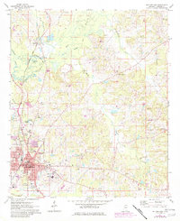
1972 Map of Philadelphia
USGS Topo · Published 1982About this map
Philadelphia serves as the focal point of this Neshoba County landscape, showing its mid-century footprint centered on the Courthouse and expanding toward Cedarlawn Cem. The town's connection to the wider region is anchored by the Illinois Central Gulf Railroad, which runs through the northern settlement of Burnside and past Burnside Lake. The terrain is defined by the winding course of the Pearl River and its many tributaries, including Ocobla Creek and Hurricane Creek, creating a complex network of wetlands and drainage basins. Educational and religious life is well-documented through rural landmarks like the Neshoba Central High Sch, Longino Ch, and Center Hill Ch. Small-scale industrial activity is evidenced by several Sandpits scattered near Sandtown, reflecting the local geology and resource extraction during this era of Mississippi's development.
Find a feature on this map
45 named features on this map. Tap any name to fly to it.
Don’t see what you’re looking for? This feature index may not catch every label — zoom into the map to look around manually.
Map Details
Editions of this 1972 Philadelphia Map
2 editions found
Other maps of this area

1953 · Meridian
USGS Topo · 1:250,000

1957 · Meridian
USGS Topo · 1:250,000

1962 · House
USGS Topo · 1:24,000

1962 · Vernon
USGS Topo · 1:24,000

1962 · Owl Creek
USGS Topo · 1:24,000

1965 · Meridian
USGS Topo · 1:250,000

1972 · Pearl River
USGS Topo · 1:24,000

1972 · Plattsburg
USGS Topo · 1:24,000
1972 · Noxapater
USGS Topo · 1:24,000

1972 · Deemer
USGS Topo · 1:24,000