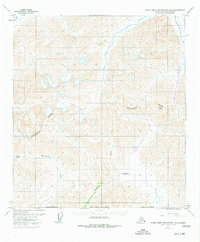
1971 Map of Philip Smith Mountains A-5
USGS Topo · Published 1977About this map
The Continental Divide snake-like path across the Brooks Range defines the hydrological and industrial landscape of this remote North Slope terrain. A significant engineering milestone is recorded here via purple revisions representing the Trans-Alaska Pipeline, which parallels the Dietrich River as it climbs toward the Atigun Pass. This corridor serves as the primary artery through the mountains, supported by a localized Camp, a Landing Strip, and a Tower positioned near the Chandalar Shelf. The map captures the transition from the southern-flowing waters of the Kuyuktuvuk Creek to the northern reaches of the Itkillik R. Remote mountain passes such as Oolah Pass highlight the traditional routes used to traverse these high ridges before the establishment of modern infrastructure.
Find a feature on this map
13 named features on this map. Tap any name to fly to it.
Don’t see what you’re looking for? This feature index may not catch every label — zoom into the map to look around manually.
Map Details
Editions of this 1971 Philip Smith Mountains A-5 Map
2 editions found
Other maps of this area

1951 · Chandler Lake
USGS Topo · 1:250,000

1951 · Chandalar
USGS Topo · 1:250,000

1951 · Brooks
USGS Topo · 1:250,000

1951 · Wiseman
USGS Topo · 1:250,000

1956 · Chandalar
USGS Topo · 1:250,000

1956 · Wiseman
USGS Topo · 1:250,000

1956 · Philip Smith Mountains
USGS Topo · 1:250,000

1956 · Chandler Lake
USGS Topo · 1:250,000

1964 · Wiseman
USGS Topo · 1:250,000

1964 · Chandalar
USGS Topo · 1:250,000