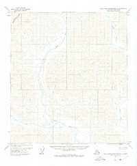
1971 Map of Philip Smith Mountains B-1
USGS Topo · Published 1975About this map
The Continental Divide cuts across the northwest corner of this remote North Slope landscape, defining the fundamental hydrological split of the Brooks Range. Flowing south from these heights, the Wind River and its intricate drainage network dominate the central terrain, while the Junjik River and Smoke Creek occupy the eastern portion of the quadrangle. This 1971 field-annotated survey, based on 1970 aerial photography, reveals a completely wild environment with no roads or trails in the area at the time of mapping. The topography is characterized by high-elevation ridges and glacial valleys, illustrating the untouched headwaters that feed into larger Alaskan river systems. It is an essential document for understanding the pristine state of the eastern Brooks Range before later developments in the North Slope Borough.
Find a feature on this map
4 named features on this map. Tap any name to fly to it.
Don’t see what you’re looking for? This feature index may not catch every label — zoom into the map to look around manually.
Map Details
Editions of this 1971 Philip Smith Mountains B-1 Map
2 editions found
Other maps of this area

1951 · Brooks
USGS Topo · 1:250,000

1951 · Arctic
USGS Topo · 1:250,000

1956 · Arctic
USGS Topo · 1:250,000

1956 · Philip Smith Mountains
USGS Topo · 1:250,000

1964 · Philip Smith Mountains
USGS Topo · 1:250,000
1971 · Philip Smith Mountains C-1
USGS Topo · 1:63,360
1971 · Philip Smith Mountains C-2
USGS Topo · 1:63,360
1971 · Philip Smith Mountains B-1
USGS Topo · 1:63,360
1971 · Philip Smith Mountains A-2
USGS Topo · 1:63,360
1971 · Philip Smith Mountains A-1
USGS Topo · 1:63,360