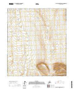
2017 Map of Philip Smith Mountains D-5 SE
USGS Topo · Published 2017About this map
The Kuparuk River carves a winding path through this high-latitude terrain, serving as the central drainage for the tundra landscape within the North Slope Borough. This 2017 survey by the U.S. Geological Survey illustrates the river's northern flow across township lines, including t7s r10e and t7s r11e. In the southeastern corner of the quadrangle, the elevation rises sharply toward the peak of Imnavait Mtn, a prominent landform that defines the local watershed. The mapping reveals a complex network of small lakes and seasonal wetlands that dominate the lower elevations, characteristic of the permafrost-underlain soils found throughout this Arctic region. While the area remains largely undeveloped, the meticulous hydrographic data and contour lines provide an essential study of the natural topography and the headwaters that feed the larger river systems of the Alaskan North Slope.
Find a feature on this map
8 named features on this map. Tap any name to fly to it.
Don’t see what you’re looking for? This feature index may not catch every label — zoom into the map to look around manually.
Map Details
Editions of this 2017 Philip Smith Mountains D-5 SE Map
This is the sole edition of this map. No revisions or reprints were ever made.
Other maps of this area

1951 · Brooks
USGS Topo · 1:250,000

1956 · Philip Smith Mountains
USGS Topo · 1:250,000

1964 · Philip Smith Mountains
USGS Topo · 1:250,000

1971 · Philip Smith Mountains C-4
USGS Topo · 1:63,360
1971 · Philip Smith Mountains D-4
USGS Topo · 1:63,360
1971 · Philip Smith Mountains D-5
USGS Topo · 1:63,360
1971 · Philip Smith Mountains C-5
USGS Topo · 1:63,360
2017 · Philip Smith Mountains D-5 NW
USGS Topo · 1:25,000
2017 · Philip Smith Mountains D-4 NW
USGS Topo · 1:25,000
2017 · Philip Smith Mountains C-5 NW
USGS Topo · 1:25,000