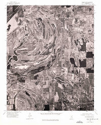
1974 Map of Philipp NW
USGS Topo · Published 1975About this map
The Tallahatchie River dominates this mid-1970s Mississippi Delta landscape, its tight meanders and dramatic oxbow scars revealing the shifting hydrology of the region. This orthophotoquad provides an aerial view of the terrain as it appeared in late 1974, showing the dense patchwork of agricultural fields that define the economy of the Delta. The settlement of Tippo is visible along a sharp bend in the river, serving as a focal point for the surrounding rural community. The imagery captures the transition between managed farmland and the wooded buffers along the riverbanks, offering a clear record of land use and river morphology before modern developments altered these drainage patterns further. It is a precise look at the intricate relationship between the river's path and the development of the small settlements that rely on it.
Find a feature on this map
2 named features on this map. Tap any name to fly to it.
Don’t see what you’re looking for? This feature index may not catch every label — zoom into the map to look around manually.
Map Details
Editions of this 1974 Philipp NW Map
This is the sole edition of this map. No revisions or reprints were ever made.
Other maps of this area

1931 · Sumner
USGS Topo · 1:48,000

1932 · Philipp
USGS Topo · 1:48,000

1932 · Tutwiler
USGS Topo · 1:48,000

1935 · Crowder
USGS Topo · 1:62,500

1935 · Sumner
USGS Topo · 1:62,500

1935 · Tutwiler
USGS Topo · 1:62,500

1935 · Philipp
USGS Topo · 1:62,500

1939 · Sumner
USGS Topo · 1:62,500

1939 · Crowder
USGS Topo · 1:62,500

1939 · Philipp
USGS Topo · 1:62,500