
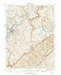
1939 Map of Philipsburg
USGS Topo · Published 1955About this map
Moshannon Creek carves a deep path through this upland landscape, serving as the boundary between Clearfield and Centre counties. The area is defined by a dense network of industrial and rural sites, from the concentration of bituminous coal operations like the Rusnak Mine and various Strip Mines near Winburne and Lanse, to the old iron-working site at Martha Furnace. The railroad infrastructure is prominent, with the New York Central and Pennsylvania lines navigating the difficult terrain to serve the mines and towns of Philipsburg, South Philipsburg, and Hawk Run.
Find a feature on this map
118 named features on this map. Tap any name to fly to it.
Don’t see what you’re looking for? This feature index may not catch every label — zoom into the map to look around manually.
Map Details
Editions of this 1939 Philipsburg Map
2 editions found
Other maps of this area

1903 · Houtzdale
USGS Topo · 1:62,500

1905 · Houtzdale
USGS Topo · 1:62,500

1908 · Bellefonte
USGS Topo · 1:62,500

1909 · Bellefonte
USGS Topo · 1:62,500

1919 · Menno
USGS Topo · 1:62,500

1920 · Altoona
USGS Topo · 1:62,500

1922 · Philipsburg
USGS Topo · 1:62,500

1922 · Altoona
USGS Topo · 1:62,500

1923 · Tyrone
USGS Topo · 1:62,500

1928 · Snow Shoe
USGS Topo · 1:48,000