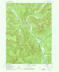
1960 Map of Phoenicia
USGS Topo · Published 1973About this map
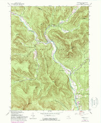
Esopus Creek carves a deep valley through the heart of the Catskill Park, serving as the primary corridor for both the New York Central Railroad and a string of mountain settlements. In this mid-century landscape, Phoenicia emerges as a central hub where Stony Clove Creek meets the main valley, flanked by high peaks like Sheridan Mtn and Tremper Mtn, the latter featuring a prominent Lookout Tower. The map documents a transition in local land use, from the traditional mountain life represented by the Shandaken Rural Cem and Our Lady of Good Counsel Ch to modern recreation indicated by a Ski Lift near Woodland Valley Creek. Educational consolidation is evident near the southern end of the sheet with the Onteora Central Sch and Bennett Sch serving the residents of Boiceville and Beechford.
Find a feature on this map
53 named features on this map. Tap any name to fly to it.
Don’t see what you’re looking for? This feature index may not catch every label — zoom into the map to look around manually.
Map Details
Editions of this 1960 Phoenicia Map
5 editions found
Other maps of this area

1892 · Kaaterskill
USGS Topo · 1:62,500

1893 · Kaaterskill
USGS Topo · 1:62,500

1894 · Kaaterskill
USGS Topo · 1:62,500

1899 · Kaaterskill
USGS Topo · 1:62,500

1900 · Phoenicia
USGS Topo · 1:62,500

1901 · Rosendale
USGS Topo · 1:62,500

1903 · Rosendale
USGS Topo · 1:62,500

1903 · Phoenicia
USGS Topo · 1:62,500

1903 · Kaaterskill
USGS Topo · 1:62,500

1903 · Slide Mountain
USGS Topo · 1:62,500