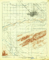
1914 Map of Phoenix
USGS Topo · Published 1932About this map
Phoenix is depicted here as a burgeoning desert hub at the dawn of the 20th century, defined by a sophisticated network of irrigation canals that transformed the arid landscape. The Salt River bisects the valley, flanked by an extensive system including the Grand Canal, Wormser Canal, and the South Branch Maricopa Canal. This infrastructure supported numerous outlying school districts such as Cartwright School, Isaac School, and Fowler School, while the Santa Fe Prescott and Phoenix RR provided vital rail connections. To the south, the Salt River Mountains rise sharply, punctuated by Telegraph Pass. This rugged terrain gives way to the Gila River Indian Reservation, where the confluence of the Gila River and Santa Cruz River is marked by the historic Lower Crossing and Gila Crossing, illustrating the area's essential role in regional transit and indigenous heritage.
Find a feature on this map
42 named features on this map. Tap any name to fly to it.
Don’t see what you’re looking for? This feature index may not catch every label — zoom into the map to look around manually.
Map Details
Editions of this 1914 Phoenix Map
4 editions found
Other maps of this area

1904 · Camelback
USGS Topo · 1:62,500

1906 · Camelsback
USGS Topo · 1:62,500

1912 · Phoenix
USGS Topo · 1:62,500

1913 · Mesa
USGS Topo · 1:62,500

1913 · Maricopa
USGS Topo · 1:62,500

1914 · Gila Butte
USGS Topo · 1:62,500

1914 · Phoenix
USGS Topo · 1:62,500

1915 · Mesa
USGS Topo · 1:62,500

1915 · Maricopa
USGS Topo · 1:62,500

1917 · Gila Butte
USGS Topo · 1:62,500