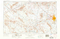
1954 Map of Phoenix
USGS Topo · Published 1968About this map
The growing metropolitan area of Phoenix anchors this mid-century landscape, surrounded by an expanse of desert plains and rugged mountain ranges. To the west, the agricultural and military character of the valley is evident through the footprint of Luke AFB and its several auxiliary fields, alongside the rural centers of Buckeye and Litchfield School. The desert floor is bisected by major washes and riverbeds, including the Hassayampa River and Agua Fria River, which define the drainage patterns between the White Tank Mountains and the Vulture Mountains.
Find a feature on this map
75 named features on this map. Tap any name to fly to it.
Don’t see what you’re looking for? This feature index may not catch every label — zoom into the map to look around manually.
Map Details
Editions of this 1954 Phoenix Map
5 editions found

Other maps of this area

1887 · Verde
USGS Topo · 1:250,000

1887 · Prescott
USGS Topo · 1:250,000

1892 · Verde
USGS Topo · 1:250,000

1892 · Prescott
USGS Topo · 1:250,000

1903 · Bradshaw Mountains
USGS Topo · 1:125,000

1903 · Congress
USGS Topo · 1:125,000

1904 · Camelback
USGS Topo · 1:62,500

1904 · Congress
USGS Topo · 1:125,000

1906 · Camelsback
USGS Topo · 1:62,500

1911 · Parker
USGS Topo · 1:125,000