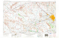
1954 Map of Phoenix
USGS Topo · Published 1970About this map
The Phoenix metropolitan area and the expansive desert basins of central Arizona are captured here during a period of significant post-war expansion. The map illustrates the burgeoning suburban landscape of the Salt River Valley, where newer communities like Sun City and Youngtown appear alongside established agricultural and transport hubs like Glendale, Avondale, and Buckeye. This urban core is anchored by Sky Harbor Municipal Airport and the heavy military presence at Luke Air Force Base, while the surrounding desert is defined by a network of seasonal washes and irrigation lifeblood provided by the Gila River and Salt River.
Find a feature on this map
130 named features on this map. Tap any name to fly to it.
Don’t see what you’re looking for? This feature index may not catch every label — zoom into the map to look around manually.
Map Details
Editions of this 1954 Phoenix Map
5 editions found

Other maps of this area

1887 · Verde
USGS Topo · 1:250,000

1887 · Prescott
USGS Topo · 1:250,000

1892 · Verde
USGS Topo · 1:250,000

1892 · Prescott
USGS Topo · 1:250,000

1903 · Bradshaw Mountains
USGS Topo · 1:125,000

1903 · Congress
USGS Topo · 1:125,000

1904 · Camelback
USGS Topo · 1:62,500

1904 · Congress
USGS Topo · 1:125,000

1906 · Camelsback
USGS Topo · 1:62,500

1911 · Parker
USGS Topo · 1:125,000