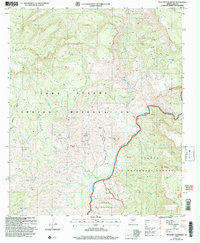
2004 Map of Picacho Colorado
USGS Topo · Published 2007About this map
The Salt River carves a deep path through this territory, serving as a natural boundary between the Fort Apache Indian Reservation and the Tonto National Forest. In the mid-2000s, this landscape was defined by its dramatic elevation changes, from the prominent Picacho Colorado in the southeast to the expansive Flat near the riverbanks. Human activity in this remote area is marked by several prospects and a mine shaft located near Medicine Butte, indicating a history of mineral exploration. Water sources are critical landmarks here, with locations like Albert Spring, Cedar Spring, and the Corral Tank providing essential points for livestock or wildlife in the arid environment. The map details a network of canyons and ridges, including the notable Mustang Ridge, while the Salt River Canyon Wilderness protects the southern reaches of the river corridor.
Find a feature on this map
36 named features on this map. Tap any name to fly to it.
Don’t see what you’re looking for? This feature index may not catch every label — zoom into the map to look around manually.
Map Details
Editions of this 2004 Picacho Colorado Map
This is the sole edition of this map. No revisions or reprints were ever made.
Other maps of this area

1922 · Chrysotile
USGS Topo · 1:125,000

1946 · Blue House Mtn
USGS Topo · 1:62,500

1949 · McFadden Peak
USGS Topo · 1:62,500

1949 · Rockinstraw Mtn
USGS Topo · 1:62,500

1950 · Rockinstraw Mtn
USGS Topo · 1:62,500

1950 · McFadden Peak
USGS Topo · 1:62,500

1951 · Blue House Mtn
USGS Topo · 1:62,500

1954 · Mesa
USGS Topo · 1:250,000

1957 · Mesa
USGS Topo · 1:250,000

1958 · Mesa
USGS Topo · 1:250,000