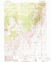
1989 Map of Picacho Peak
USGS Topo · Published 1989About this map
Shenandoah City stands as a focal point of human settlement in this high-desert mining district within the Wah Wah Mountains of Utah. The landscape is defined by the heavy concentration of extractive industry along the eastern slopes, where numerous shafts, adits, and prospects follow the mineral veins of the Mammoth Canyon and Moscow Wash areas. This 1989 provisional map, based on field checks dating back to 1958 and 1986, documents the density of small-scale mining operations that shaped the local economy and social history. Transportation through the hills relies on a network of unimproved roads and trails connecting isolated water sources such as Woodhouse Spring and Wheeler Spring, which were vital for sustaining the remote camps and livestock in this arid environment.
Find a feature on this map
1 named feature on this map. Tap any name to fly to it.
Don’t see what you’re looking for? This feature index may not catch every label — zoom into the map to look around manually.
Map Details
Editions of this 1989 Picacho Peak Map
This is the sole edition of this map. No revisions or reprints were ever made.
Other maps of this area

1953 · Ninemile Knoll
USGS Topo · 1:24,000

1953 · Milford Flat
USGS Topo · 1:24,000

1953 · Richfield
USGS Topo · 1:250,000

1958 · Richfield
USGS Topo · 1:250,000

1958 · Thermo
USGS Topo · 1:62,500

1958 · Milford
USGS Topo · 1:62,500

1958 · Milford
USGS Topo · 1:24,000

1959 · Frisco
USGS Topo · 1:62,500
1971 · Burns Knoll
USGS Topo · 1:24,000

1980 · Wah Wah Mts. South
USGS Topo · 1:100,000