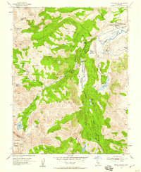
1954 Map of Pickel Meadow
USGS Topo · Published 1959About this map
The Marine Corps Cold Weather Camp occupies the northern reaches of Pickel Meadow, marking a distinct military footprint within the Toiyabe National Forest. This high-altitude basin, where the West Walker River meanders through open flats, serves as a primary hub for mountain operations. The map documents the intersection of specialized military training grounds with established natural landmarks, including the nearby Leavitt Sta (Site) and the extensive trail and water network surrounding Leavitt Meadow.
Find a feature on this map
42 named features on this map. Tap any name to fly to it.
Don’t see what you’re looking for? This feature index may not catch every label — zoom into the map to look around manually.
Map Details
Editions of this 1954 Pickel Meadow Map
4 editions found
Other maps of this area

1896 · Dardanelles
USGS Topo · 1:125,000

1898 · Dardanelles
USGS Topo · 1:125,000

1909 · Bridgeport
USGS Topo · 1:125,000

1911 · Bridgeport
USGS Topo · 1:125,000

1920 · Bridgeport
USGS Topo · 1:125,000

1948 · Walker Lake
USGS Topo · 1:250,000

1954 · Chris Flat
USGS Topo · 1:24,000

1954 · Pickel Meadow
USGS Topo · 1:24,000

1954 · Fales Hot Springs
USGS Topo · 1:24,000

1954 · Lost Cannon Peak
USGS Topo · 1:24,000