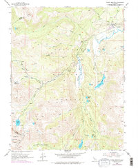
1954 Map of Pickel Meadow
USGS Topo · Published 1978About this map
The USMC Mountain Warfare Sch dominates the northern reaches of Pickel Meadow, illustrating the region's mid-century military importance for high-altitude training. Located along the West Walker River, this alpine landscape in Toiyabe National Forest features a network of glacial lakes and dramatic elevation changes. The presence of the Landing Strip and the historic Leavitt Sta (Site) suggests the area's role as a vital transit point through the eastern Sierra Nevada. The terrain is defined by the convergence of several major water systems, including Leavitt Creek and the West Fork Walker River, which feed into numerous remote basins such as Poore Lake and Leavitt Lake. Along the western boundary, the map captures the transition into the Stanislaus National Forest at the headwaters of Kennedy Canyon.
Find a feature on this map
39 named features on this map. Tap any name to fly to it.
Don’t see what you’re looking for? This feature index may not catch every label — zoom into the map to look around manually.
Map Details
Editions of this 1954 Pickel Meadow Map
4 editions found
Other maps of this area

1896 · Dardanelles
USGS Topo · 1:125,000

1898 · Dardanelles
USGS Topo · 1:125,000

1909 · Bridgeport
USGS Topo · 1:125,000

1911 · Bridgeport
USGS Topo · 1:125,000

1920 · Bridgeport
USGS Topo · 1:125,000

1948 · Walker Lake
USGS Topo · 1:250,000

1954 · Chris Flat
USGS Topo · 1:24,000

1954 · Pickel Meadow
USGS Topo · 1:24,000

1954 · Fales Hot Springs
USGS Topo · 1:24,000

1954 · Lost Cannon Peak
USGS Topo · 1:24,000