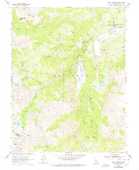
1954 Map of Pickel Meadow
USGS Topo · Published 1978About this map
USMC Mountain Warfare Sch anchors the high mountain landscape of this 1954 survey, located near the confluence of Silver Creek and the West Fork Walker River. The map details the remote transition from Pickel Meadow to Leavitt Meadow, documenting established military training sites and historical waypoints like the Leavitt Sta (Site). The terrain is defined by a dense network of alpine lakes and dramatic drops, including Leavitt Falls and Sardine Falls. Evidence of earlier pack routes and seasonal grazing is visible across the Toiyabe National Forest, where labels such as Sardine Meadow and Kennedy Canyon indicate the area's long-standing use for transit and resource management. Significant water bodies like Leavitt Lake, Fremont Lake, and Roosevelt Lake are meticulously charted along with the county line between Alpine and Mono.
Find a feature on this map
38 named features on this map. Tap any name to fly to it.
Don’t see what you’re looking for? This feature index may not catch every label — zoom into the map to look around manually.
Map Details
Editions of this 1954 Pickel Meadow Map
4 editions found
Other maps of this area

1896 · Dardanelles
USGS Topo · 1:125,000

1898 · Dardanelles
USGS Topo · 1:125,000

1909 · Bridgeport
USGS Topo · 1:125,000

1911 · Bridgeport
USGS Topo · 1:125,000

1920 · Bridgeport
USGS Topo · 1:125,000

1948 · Walker Lake
USGS Topo · 1:250,000

1954 · Chris Flat
USGS Topo · 1:24,000

1954 · Pickel Meadow
USGS Topo · 1:24,000

1954 · Fales Hot Springs
USGS Topo · 1:24,000

1954 · Lost Cannon Peak
USGS Topo · 1:24,000