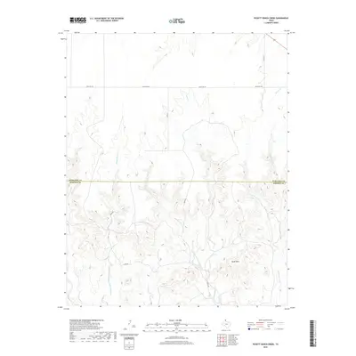
2019 Map of Pickett Ranch Creek
USGS Topo · Published 2019About this map
The high plains of the Texas Panhandle define this landscape, where the boundary between Ochiltree Co and Roberts Co bisects a complex network of drainage systems. The terrain is characterized by the prominent Tandy Mesa and the deep incisions created by Pickett Ranch Cr and Point Creek. These seasonal waterways, including the Northwest Fork Point Cr and Hackberry Creek, represent the primary natural features in an area dominated by ranching and rural transport. The local road network is clearly delineated, featuring Ranch Rd 281 running east-west across the northern section, supported by local routes such as Hanks Rd and Tandy Rd. This 2019 survey documents the modern layout of these cattle-country lands, showing how contemporary infrastructure like Co RD 25 and Co RD 23 navigates the distinct mesa-and-creek topography.
Find a feature on this map
14 named features on this map. Tap any name to fly to it.
Don’t see what you’re looking for? This feature index may not catch every label — zoom into the map to look around manually.
Map Details
Editions of this 2019 Pickett Ranch Creek Map
This is the sole edition of this map. No revisions or reprints were ever made.
Other maps of this area
1954 · Perryton
USGS Topo · 1:250,000
1954 · Amarillo
USGS Topo · 1:250,000
1958 · Perryton
USGS Topo · 1:250,000
1958 · Amarillo
USGS Topo · 1:250,000
1971 · Dry Creek NE
USGS Topo · 1:24,000
1972 · Horse Creek North
USGS Topo · 1:24,000
1972 · East Dry Creek
USGS Topo · 1:24,000
1973 · Sourdough Creek NE
USGS Topo · 1:24,000
1973 · Pickett Ranch Creek
USGS Topo · 1:24,000
1973 · Lake Fryer
USGS Topo · 1:24,000