
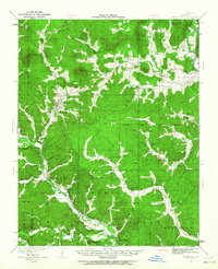
1932 Map of Piedmont
USGS Topo · Published 1955About this map
Piedmont serves as the primary hub of this Ozark landscape, situated where the foothills meet the Black Missouri River. In the early 1930s, the region's economy and movement were dictated by the Missouri Pacific railroad corridor, which links the settlements of Gads Hill, Leeper, and Mill Spring. The terrain is characterized by high peaks such as Clark Mtn and Grassy Mtn, with a dense network of country schools like Hog Eye Sch and Peachtree Sch serving isolated hollows. To the northeast, the St Francois River defines the border near Sam A Baker State Park. The map captures a moment before modern infrastructure bypassed these small communities, preserving the locations of rural centers like Patterson and the small church at Lebanon Ch.
Find a feature on this map
93 named features on this map. Tap any name to fly to it.
Don’t see what you’re looking for? This feature index may not catch every label — zoom into the map to look around manually.
Map Details
Editions of this 1932 Piedmont Map
2 editions found
Other maps of this area

1926 · Des Arc
USGS Topo · 1:62,500

1929 · Des Arc
USGS Topo · 1:62,500

1930 · Coldwater
USGS Topo · 1:62,500

1934 · Greenville
USGS Topo · 1:62,500

1934 · Williamsville
USGS Topo · 1:48,000

1935 · Poplar Bluff
USGS Topo · 1:62,500

1935 · Piedmont
USGS Topo · 1:62,500

1939 · Greenville
USGS Topo · 1:62,500

1939 · Poplar Bluff
USGS Topo · 1:62,500

1940 · Williamsville
USGS Topo · 1:62,500