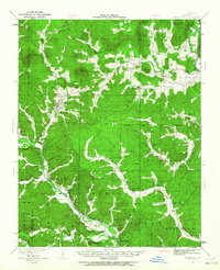
1932 Map of Piedmont
USGS Topo · Published 1964About this map
Piedmont serves as the central hub of this Missouri Ozarks landscape, where the Missouri Pacific railroad winds along the Black River corridor. The geography is defined by a dense network of rural schools and churches that anchored early 1930s communities, from Hog Eye Sch near the St Francis River to the Lebanon Ch in the interior hills. The terrain is characterized by named knobs and mountains like Chlore Mtn and Grassy Mtn, interspersed with deep hollows and creek valleys.
Find a feature on this map
78 named features on this map. Tap any name to fly to it.
Don’t see what you’re looking for? This feature index may not catch every label — zoom into the map to look around manually.
Map Details
Editions of this 1932 Piedmont Map
2 editions found
Other maps of this area

1926 · Des Arc
USGS Topo · 1:62,500

1929 · Des Arc
USGS Topo · 1:62,500

1930 · Coldwater
USGS Topo · 1:62,500

1932 · Piedmont
USGS Topo · 1:62,500

1934 · Greenville
USGS Topo · 1:62,500

1934 · Williamsville
USGS Topo · 1:48,000

1935 · Poplar Bluff
USGS Topo · 1:62,500

1935 · Piedmont
USGS Topo · 1:62,500

1939 · Greenville
USGS Topo · 1:62,500

1939 · Poplar Bluff
USGS Topo · 1:62,500