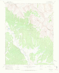
1967 Map of Pieplant
USGS Topo · Published 1971About this map
The Continental Divide winds through the high-altitude terrain of the central Rockies in the mid-1960s, marking the intersection of the Gunnison, White River, and San Isabel national forests. This area is defined by its mining heritage, centered on the Pieplant Mine and the nearby Pieplant Mill (Site) along Pieplant Creek. These features indicate a localized industrial footprint within a landscape otherwise dominated by towering peaks like Jenkins Mountain and Grizzly Peak. Transportation through this steep geography is limited to specialized routes, including the rugged Timberline Trail and various unnamed Jeep Trails. The presence of the Dinner Station Campground along the Taylor River suggests the transition of this former mining district into a destination for mountain recreation and backcountry exploration during this era.
Find a feature on this map
29 named features on this map. Tap any name to fly to it.
Don’t see what you’re looking for? This feature index may not catch every label — zoom into the map to look around manually.
Map Details
Editions of this 1967 Pieplant Map
3 editions found
Other maps of this area

1889 · Leadville
USGS Topo · 1:125,000

1891 · Leadville
USGS Topo · 1:125,000

1909 · Mount Jackson
USGS Topo · 1:125,000

1911 · Mount Jackson
USGS Topo · 1:125,000

1934 · Taylor Park
USGS Topo · 1:62,500

1935 · Mount Elbert
USGS Topo · 1:62,500

1937 · Taylor Park
USGS Topo · 1:62,500

1938 · Mount Elbert
USGS Topo · 1:62,500

1939 · Mount Elbert
USGS Topo · 1:62,500

1942 · Leadville
USGS Topo · 1:125,000