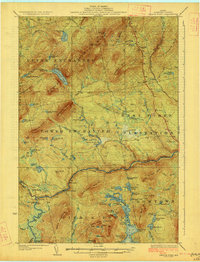
1927 Map of Pierce Pond
USGS Topo · Published 1927About this map
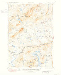
West Forks Plantation and the surrounding unorganized townships of Somerset County define this 1920s landscape of the Maine North Woods. The Dead River carves a significant path through the southern half of the map, featuring Grand Falls and the Dead River Dam. This era shows a transition in the region's wilderness utility, where logging infrastructure like Depot Camp and Hayden Landing exists alongside early sporting and tourism sites. Sporting camps such as the Appletree Inn, Comber Inn, and Pierce Pond Camps are clustered near the waterways, signaling the area's reputation for outdoor recreation. High peaks including Coburn Mtn—noted with a Lookout Sta—and Hurricane Mtn rise sharply above the dense network of ponds and bogs, including the expansive Upper Pierce Pond and Johnson Bog.
Find a feature on this map
89 named features on this map. Tap any name to fly to it.
Don’t see what you’re looking for? This feature index may not catch every label — zoom into the map to look around manually.
Map Details
Editions of this 1927 Pierce Pond Map
6 editions found

Other maps of this area

1903 · Bingham
USGS Topo · 1:62,500

1905 · Bingham
USGS Topo · 1:62,500

1905 · The Forks
USGS Topo · 1:62,500

1907 · The Forks
USGS Topo · 1:62,500

1921 · Brassua Lake
USGS Topo · 1:62,500

1922 · Long Pond
USGS Topo · 1:62,500

1923 · Brassua Lake
USGS Topo · 1:62,500

1923 · Attean
USGS Topo · 1:62,500

1924 · Long Pond
USGS Topo · 1:62,500

1925 · Pierce Pond
USGS Topo · 1:48,000
Featured Places
- West Forks, ME
- Hayden Landing, Pierce Pond Township
- Upper Enchanted Township, ME
- Johnson Mountain Township, ME
- Bowtown Township, ME