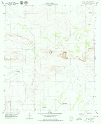
1979 Map of Pierce Ranch
USGS Topo · Published 1979About this map
Pierce Ranch sits at the heart of this Hudspeth County landscape, illustrating the water-dependent ranching operations of West Texas in the late 1970s. The terrain is defined by isolated peaks and ridges, most notably Round Mountain, with a network of catchments such as Ramsey Tank, Horton Tank, and Morris Tank providing critical resources for livestock in an arid environment. Transportation and infrastructure reflect the region's low-density settlement and varied utility, featuring the Milehigh Community Airport and dedicated Landing Strips alongside more rugged routes like a Jeep Trail. Evidence of local industry appears in the form of a Gravel Pit, while the presence of a Well and several numbered water tanks points to the systematic management of groundwater and surface runoff essential for sustaining the cattle ranching economy of this high-altitude desert plateau.
Find a feature on this map
13 named features on this map. Tap any name to fly to it.
Don’t see what you’re looking for? This feature index may not catch every label — zoom into the map to look around manually.
Map Details
Editions of this 1979 Pierce Ranch Map
This is the sole edition of this map. No revisions or reprints were ever made.
Other maps of this area

1895 · Sierra Blanca
USGS Topo · 1:125,000

1948 · Triple Hill
USGS Topo · 1:62,500

1954 · Van Horn
USGS Topo · 1:250,000

1958 · Van Horn
USGS Topo · 1:250,000

1964 · Dome Peak
USGS Topo · 1:24,000

1964 · Lasca
USGS Topo · 1:24,000
1964 · Sierra Blanca
USGS Topo · 1:24,000

1973 · Norton Mesa
USGS Topo · 1:24,000
1973 · Movie Mountain
USGS Topo · 1:24,000
1979 · Black Hills
USGS Topo · 1:24,000