
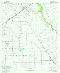
1952 Map of Pierce
USGS Topo · Published 1953About this map
The settlement of Pierce serves as the focal point for this early 1950s study of Wharton County, situated along the Southern Pacific rail line. The landscape is defined by an extensive system of levees and man-made drainage, reflecting the heavy investment in land reclamation and agricultural engineering required for this coastal prairie region. A prominent Oil Field occupies the northwestern corner, indicating the industrial footprint of petroleum extraction alongside the traditional ranching and farming economy.
Find a feature on this map
11 named features on this map. Tap any name to fly to it.
Don’t see what you’re looking for? This feature index may not catch every label — zoom into the map to look around manually.
Map Details
Editions of this 1952 Pierce Map
2 editions found
Other maps of this area

1951 · Danevang
USGS Topo · 1:24,000

1952 · Lane City SE
USGS Topo · 1:24,000

1952 · Lane City
USGS Topo · 1:24,000

1953 · Wharton
USGS Topo · 1:24,000

1953 · Glen Flora
USGS Topo · 1:24,000

1953 · Seguin
USGS Topo · 1:250,000

1958 · Seguin
USGS Topo · 1:250,000

1960 · New Taiton
USGS Topo · 1:24,000

1965 · El Campo
USGS Topo · 1:24,000
1965 · El Campo SE
USGS Topo · 1:24,000