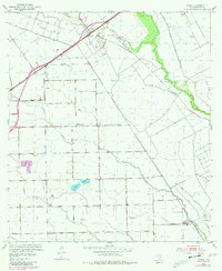
1952 Map of Pierce
USGS Topo · Published 1981About this map
Pierce sits at a critical rail intersection in Wharton County, where the Southern Pacific line cuts through a landscape defined by ranching and resource extraction. The area's mid-century rural infrastructure is clearly visible, anchored by local education centers like Blue Creek Sch and the already noted Tres Palacios Sch (Abandoned). The terrain is a complex network of waterways, including Jones Creek, Blue Creek, and the headwaters of the Tres Palacios River. Significant land use is dedicated to the Oil Field operations in the northwest, marked by numerous Oil Wells that speak to the industrial character of the coastal prairie during this era. A system of levees follows the winding course of the creeks, illustrating early efforts to manage the hydrology of these flat Texas lowlands.
Find a feature on this map
14 named features on this map. Tap any name to fly to it.
Don’t see what you’re looking for? This feature index may not catch every label — zoom into the map to look around manually.
Map Details
Editions of this 1952 Pierce Map
2 editions found
Other maps of this area

1951 · Danevang
USGS Topo · 1:24,000

1952 · Lane City SE
USGS Topo · 1:24,000

1952 · Lane City
USGS Topo · 1:24,000

1952 · Pierce
USGS Topo · 1:24,000

1953 · Wharton
USGS Topo · 1:24,000

1953 · Glen Flora
USGS Topo · 1:24,000

1953 · Seguin
USGS Topo · 1:250,000

1958 · Seguin
USGS Topo · 1:250,000

1960 · New Taiton
USGS Topo · 1:24,000

1965 · El Campo
USGS Topo · 1:24,000