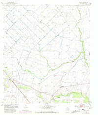
1952 Map of Egypt
USGS Topo · Published 1981About this map
The lowlands of Wharton County are defined here by a network of drainage ditches and windmills, where agricultural land-use intersects with mid-century petroleum extraction. Egypt Oil Field and Spanish Camp Oil Field dominate the central and eastern sections, showing an landscape dotted with gas wells and pipe lines during the early 1950s. The settlement of Egypt sits along the Atchison Topeka and Santa Fe railroad, serving as a focal point for the local community near Peach Creek.
Find a feature on this map
19 named features on this map. Tap any name to fly to it.
Don’t see what you’re looking for? This feature index may not catch every label — zoom into the map to look around manually.
Map Details
Editions of this 1952 Egypt Map
2 editions found
Other maps of this area

1952 · Egypt
USGS Topo · 1:24,000

1953 · Wharton
USGS Topo · 1:24,000

1953 · Hungerford
USGS Topo · 1:24,000

1953 · Glen Flora
USGS Topo · 1:24,000

1953 · Seguin
USGS Topo · 1:250,000

1956 · Wallis
USGS Topo · 1:62,500

1957 · Eagle Lake
USGS Topo · 1:62,500

1958 · Seguin
USGS Topo · 1:250,000

1959 · Bonus
USGS Topo · 1:24,000

1960 · Lissie
USGS Topo · 1:24,000