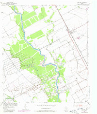
1952 Map of Lane City
USGS Topo · Published 1980About this map
The Colorado River meanders through this portion of Wharton County, defining a landscape of riparian corridors and active petroleum extraction. Near Lane City, the Atchison Topeka and Santa Fe railroad line runs parallel to the highway, serving as a vital transport link for the region's agricultural and industrial output. The map reveals an extensive network of Oil Wells and infrastructure across the Old Field, illustrating the post-war energy boom that shaped local economies in the early 1950s. Smaller waterways like Jarvis Creek and Jones Creek feed into the main river channel, while man-made features such as the Spoil Bank and numerous levees indicate significant land management and reclamation efforts by the Texas Reclamation Department to control the river's floodplain.
Find a feature on this map
16 named features on this map. Tap any name to fly to it.
Don’t see what you’re looking for? This feature index may not catch every label — zoom into the map to look around manually.
Map Details
Editions of this 1952 Lane City Map
3 editions found
Other maps of this area

1950 · Houston
USGS Topo · 1:250,000

1951 · Danevang
USGS Topo · 1:24,000

1952 · Lane City SE
USGS Topo · 1:24,000

1952 · Pledger
USGS Topo · 1:24,000

1952 · Lane City
USGS Topo · 1:24,000

1952 · Van Vleck
USGS Topo · 1:24,000

1952 · Pierce
USGS Topo · 1:24,000

1953 · Wharton
USGS Topo · 1:24,000

1953 · Glen Flora
USGS Topo · 1:24,000

1953 · Boling
USGS Topo · 1:24,000