
1952 Map of Pledger
USGS Topo · Published 1953About this map
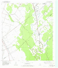
The winding course of Caney Creek and its many oxbows dominate this mid-century look at the coastal prairie, where agricultural drainage and rail infrastructure define the landscape. Along the Wharton and Matagorda County line, small communities like Pledger and Magnet serve as focal points for the region's transport and industrial activity. Evidence of the local economy is clear through the presence of an Oil Well and the extensive network of the Gulf Colorado and Santa Fe and Southern Pacific railroads. The area's social history is anchored by sites like Bethlehem Ch and Union Cem. Large-scale landscape modifications are also visible, including several segments of Levee and Spoil Bank alongside Water Hole Creek, illustrating the efforts to manage water across the flat terrain.
Find a feature on this map
22 named features on this map. Tap any name to fly to it.
Don’t see what you’re looking for? This feature index may not catch every label — zoom into the map to look around manually.
Map Details
Editions of this 1952 Pledger Map
Other maps of this area

1950 · Houston
USGS Topo · 1:250,000

1952 · Danciger
USGS Topo · 1:24,000

1952 · Ashwood
USGS Topo · 1:24,000

1952 · Lane City SE
USGS Topo · 1:24,000

1952 · Lane City
USGS Topo · 1:24,000

1952 · Van Vleck
USGS Topo · 1:24,000

1953 · Guy
USGS Topo · 1:24,000

1953 · Wharton
USGS Topo · 1:24,000

1953 · Boling
USGS Topo · 1:24,000

1953 · Seguin
USGS Topo · 1:250,000